

When was this page last updated : January 05, 2021
To order, or mention errors : please contact me here
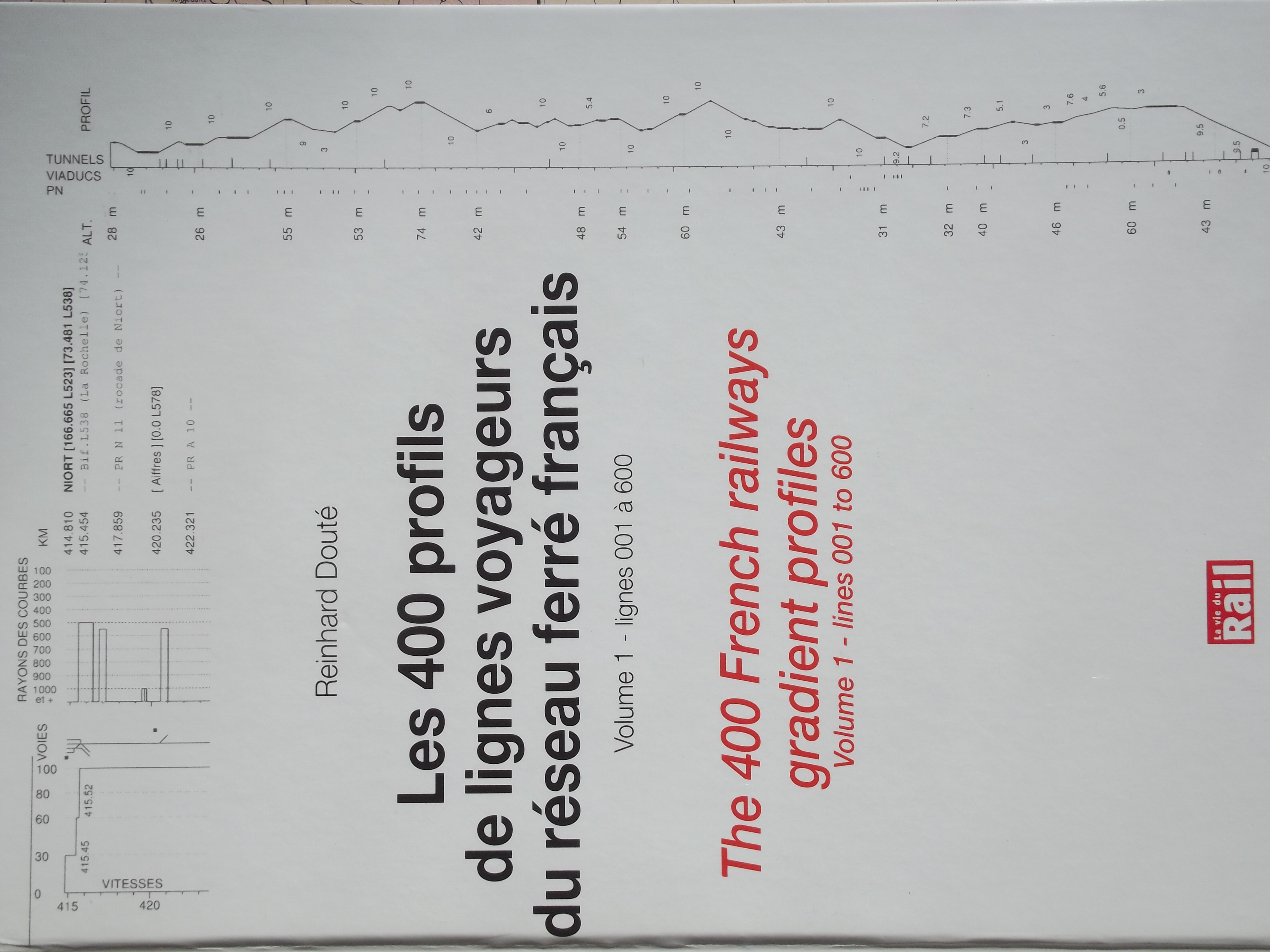
The first edition of this book (with 2 volumes) was published in August, 2011. Its new ambition, once the extended and revised edition has been published, it to present line profiles for virtually the whole of the network at its peak (in the 1930s), of course with the addition of all lines opened since then (mostly high speed lines, but also suburban lines in the Paris region e.g. Aulnay - Roissy or the Evry line - nicknamed "Plateau line"). Very short lines (less than 7 kms) are excluded.
The first edition (Volumes 1 & 2) has been marketed by Editions La Vie Du Rail until June, 2019. This was then taken over RD-RAIL (my personal, very small publishing company...) at less than half price (29,90 € for one volume, 49,90 € for both volumes together, 74,90 € for these two volumes combined with the RD-RAIL book on rail journey times in France 1914-2014). As a general rule, postage comes on top of that, but if you live in or near Paris it may be possible to arrange a meeting there, thereby saving substantial postage costs (because of the weight of the books : 1.3 kgs each).
As a gift : for any purchase, yout will receive (by e-mail) the 4 PDF files for the 4 high speed lines which entered service in 2016-2017 : LGV-BPL (Bretagne Pays de Loire i.e. Le Mans - Rennes), LGV-CNM (Nîmes - Montpellier bypass), LGV-Est Phase 2, LGV-SEA (Sud Europe Atlantique i.e. Tours - Bordeaux).
EXTRA FILES, AVAILABLE HERE (free download) :
(most of these files were edited in 2011 and should be revised because of the various high speed lines which were opened since then...)All these files, except n° 5 (straight sections) and 6 (level sections), which are ideas which came up later than the time of publication, are available online on the website, as indicated in the "Line profils" books. Other additions may be considered : siggestions by e-mails are welcome, and will be processed depending on available time.
INFORMATION ON THE CONTINUOUS UPDATE OF PROFILES ALREADY PUBLISHED :
The first notable step was the production of the line profiles for the high speed lines which opened in 2016-2017 :Many other updates occurred since 2011, which were mostly :
No less than 377 individual changes (some minor, others more like a complete overhaul e.g. in the case of Line 519 Nantes - Châteaubriant) were made between july, 2011 (when the collection of data for publication was over) and september, 2014. Today's figure probably stands above 1,000.
The list of these 2011-2014 changes is available here. "!E2" at the beginning of each line (for "Edition 2") is merely a help for searching the text files of the line profiles. This enables to produce any time an updated file similar to this one, with all updates carried out beween 2011 and today.
INFORMATION ON THE PROGRESS OF THE PREPARATION OF THE EXTENDED EDITION OF LINE PROFILES :
Following a decision taken at the end of 2020, , this extended edtion (previously
named "Part 2") when the view was to incorporate only not-yet-published profiles, in other words mostly freight-only
or now closed or even dismantled lines, corresponds to the maximum extent (around 1930) of the network, supplemented by
lines opened since then (high speed lines + a few sections in the Ile-de-France region). This will also include,
as much as possible, lines opened to passenger traffic but transferred to other bodies (RATP, Corsica, Provence...
This means that there will be a combination, over each geographic area, revised profiles (those published in 2011)
and new profiles (all lines not previously included).
The geographic coverage will be divided in the following manner :
The reason being mostly data availability (thanks to the Compagnie du Midi for its line profiles...)
the first publication, scheduled for the end of 2021, will be Volume 5 i.e. the territory of the former
Compagnie du Midi, in other words all lines south and/or west of : Le Verdon - Bordeaux - Montauban
- Castres - Rodez - Espalion - Neussargues - Millau - Le Vigan - Lodève - Montpellier - Montbazin-Gigean - Sète
The other 7 volumes will be published from 2022 to probably 2026, with an expectation of 2 volumes per year, depending on
(1) the author's availability, (2) the priority given to another publication in the field of journey times, and (3) how much
research work will need to be undertaken, as there is little data easily available on lines which are out of use today.
Still, one may note that SNCF's Le Mans archives (SARDO) have a great wealth of information available, in the shape of
original construction plans for a number of lines. Massive photographic work has been carried out between 2017 and 2019,
producing about 4,500 pictures of the old documents, in 290 files, all waiting now to be processed. Thse documents should
provide the line profile, curve radiuses, level crossings, bridges and tunnels, but not line speeds. As regards station layouts,
a choice will need to be made between the original layout and the one that is shown by line profile booklets from 1930-1960.
Line speeds will often come from the AFAC's 1957 collection of RTs ("Renseignements Techniques", a general line description)...
for lines that still had traffic in 1957 ; but also from older documents e.g. "Midi" timetables of 1930 (which did provide
line speeds).
As regards the revision of profiles published in 2011, it will be complete for level crossings and overbridges, with a number of
removed LC / new bridges... often related. The position of station buildings (vs the tracks) will be systematically checked,
which was not always so in the 2011 edition. Some profiles will be divided e.g. 640/1 Bordeaux - Agen and 640/2 Agen - Toulouse
will become 4 profiles, with sectional boundaries at Marmande, Agen and Montauban. This will markedly improve readability but will
also enable to show more information such as (1) freight sidings, and (2) (much in the same way as curves and straight sections)
showing (in the central part of thr profile) main gradient, uphill and downhill, and level sections, something which has been
systematically done since late 2020 for new profiles.
A few new global profiles (named "vue d'ensemble"/global view) will be created for the longest lines. In the case of Volume 5,
this will be so for lines 640 Bordeaux - Sète and 650 Toulouse - Bayonne. As a reminder, these global views already exist :
For this new publication, the drawing software will of course undergo some minor modifications : one of them (already
carried out) enables longer text lines in the profile's central section - the current limit of 68 characters being
often a bit low. The visual identification of all profiles of this extended edition will be simple : their title will be
of the "A > B" type, instead of "A - B" previously, which has the extra advantage of enabling a rigorous naming
of station names, with "space - space" if it incorportates two distinct locations. Still on the matter of station names,
choices will have to be made between the historical name and the current one, as in the case of Tournemire (historical name,
which will be selected for lines 727 Tournemire > Le Vigan and 728 Tournemire > St-Affrique) and Tournemire - Roquefort
(current name, valid for 722 Béziers > Neussargues). Final principles will be explained in due time in the introductory text
at the beginning of each volume.
A noteworthy characteristic of the new profiles will be the systematic display of "what might have been" as regards
maximum permitted speeds, because the secondary lines, far from begin "poorly built", nearly always could have permitted
much higher speeds than was they actually did... if adequate motive power had been available too. On "Midi" territory,
permitted speeds were usually in the 50-75 km/ bracket (90 in a few rare cases), but in most cases could technically
have stood between 85 and 100 km/h, sometimes 110... This is of course part of the explanation for the very low
average speeds that were so commun on these lines (see the "Rail journey times 1914-2014" book), a major reason
for the later demise of these (very) rural lines...
A final but worthy improvement in this extended edition will be the quality of the profile : the systematic use
of the Geoportail cartographic tool in addition to "historical" IGN levelling data not only helps eliminating some
major errors in profile data, but also raises profile quality to 1 m altitude precision, instead of around 2 m before,
and this was not without difficulties. This improvement will apply to all profiles, whether revised or new.